You may check out all the available trips and book one that suits you.
Continue Browsing TripsYou will be greeted by the team of Tour De Rakaposhi at Islamabad International airport then transfer you along with your luggage to centrally located in Islamabad. After rest your guide will brief and gear check. Overnight stay in Islamabad.
Distance: 30km / Driving Hours: 01 hr / Altitude: 540m / Activities: Sightseeing.
a) Weather permitting; we take a spectacular flight to the high mountain region of Baltistan in the northeast. On a clear day, we should be able to see Nanga Parbat (8124m) and K2 (8611m) towering above all other mountains. (It is quite possible adverse weather in Islamabad or Skardu may affect our flight plans and make it necessary to drive by the Karakoram Highway to Skardu, a journey of approx. two days).
b) In case of cancellation of flight drive 10-12hrs by air-conditioned coach/car to Chilas (480km) on the Karakoram highway. Overnight at Shangri-La Indus View Hotel or Panorama hotel.
DETAILED
a) Overnight Masherbrum Hotel. Preparations for our trek and depending on our time of arrival into Skardu, there may be time to visit the town and possibly an excursion to Kachura Lake situated at the edge of the valley. Skardu is the regional capital of Baltistan, lying at the edge of a broad floodplain that is the confluence of the Shyok, Indus, and Basha Rivers.
b) If we are driving the road journey today will be 7-8 hrs. to Skardu (275km). On route are spectacular views of Nanga Parbat (8125m) overnight Hotel.
We will travel by jeep with our crew and supplies along the Shigar and Braldu valleys to Askole. Villages in Shigar have changed little in over five hundred years; farms with fields of barley, wheat, and vegetables surrounded by stone walls and stands of poplar, willow, and apricot trees. The apricot is a very important crop in the north, having a multitude of uses for the Baltit and Hunzakuts people. Villagers greet us as we pass through on the rugged dirt and stone road that leads to Baltoro. As we approach, the landscapes become desert-like, and once within the sheer valley of the Braldu, it is necessary to cross the river several times by suspension bridges. At various points, the road may have collapsed due to erosion and we will transfer the gear across on foot to a vehicle on the other side.
After the considerable organization of equipment, supplies, and porter loads for the journey ahead, we commence trekking towards Jhola. The valley opens out to reveal the Biafo Glacier flowing for more than fifty kilometers from the Hispar La pass to the Braldu. We have our first taste of moraine walking as we cross the snout of the glacier and descend to our lunch spot beside the river. We also experience the harsh, stark environment that forms the base of these great mountains.
Our route takes us to the confluence of the Braldu and Dumordo Rivers where the infamous flying fox or ‘Jola’ is located. It is still there, however, a footbridge has now been built making the passage much easier from every perspective. (Consider individual passage of 50 to 70 people with loads, compared with walking straight across a steel bridge!). In past years it was necessary to make a high traverse across a rocky face and descend steeply to the riverside of the Dumordo to gain the flying fox. There is now a safe and pleasant pathway above the river. It is this valley, fed by the Panmah Glacier that was once a passage between Baltistan and Yarkand across the West Mustagh Pass (5370m) into China. Once across, we descend beside the river to the Braldu and then follow along its banks to our camp.
The route is mainly at riverside throughout the day, switching up and down somewhat according to the level of erosion and water levels of the Braldu. The Masherbrum Group may be glimpsed to our right via the Xiangang Valley. The range is a vast array of peaks that extend almost the full length of the southern side of Baltoro. Walking conditions are hot and dry and care must be taken to prevent sunburn, especially when most members will have come from a southern winter! As we approach camp several small glacially-fed rivulets flow down from the north and the first peaks of the Trango and Uli Biaho group appear on the distant ridgeline. The vast snout of the Baltoro glacier, the fourth-longest in Pakistan, is also visible but it’s hard to gather a sense of scale from here
Day
An important preparatory stage for our crew and porters. Our goats are slaughtered and roti (bread) baked throughout the day for the journey ahead on the glacier. It is a welcome opportunity for us to relax, read and take photos. Perhaps do some washing and simply enjoy being in the mountains.
Making the short approach to the glacier, the great expanse of ice stretching across the Braldu comes into perspective when we see the many porters forming an ant-like trail across it. Ice cliffs tower more than sixty meters above the turbulent waters at the origin of the Braldu River. As a result of its continually changing nature, the glacial moraine may be difficult to trek upon at this stage and our route varies somewhat each time. One should be prepared for a hard day of walking and carry plenty of fluid. Once at the other side, the trail will hug the side and occasionally necessitate a glacier or river crossing. There are now uninterrupted views of Paiju Peak (6610m), Uli Biaho group, Trango Group, and Cathedral Group – a majestic, spired collection of mountains that the Karakoram is so well known for. Behind us, the steep grassy slopes make high grazing pastures for ibex and the rocks are home to mouse hares (Pikas) and colorful hoopoe birds which forage for food scraps.
An easier day’s walk, following a good trail at the side of the Baltoro with two feeding glaciers to cross en-route. It is Great Trango (5844m), facing eastwards, that is considered the greatest cliff face in the world and the point from which two Australians made a world record base jump in 1992. On the trail, pony trains carrying supplies to army camps are often passed and occasional helicopters overhead provide a reminder of our proximity to the disputed territory of Kashmir nearby. The grassy camp of Urdukas is well located before the mountains and is our last before continuing glacial camps. If the weather is clear at the head of the valley, we may see Broad Peak (8050m) and Gasherbrum IV (7930m), two of the most prominent peaks of the region.
Descending rugged terrain onto the glacier, we cross to the center where it is easier trekking.
We weave over rolling mounds of rock and scree, not unlike that of a quarry, and head almost in a direct path to GIV. We are in fact steering slightly northwards to a moraine hollow where Goro II is situated. The vast glacial highway of the Yermanendu feeds in from the south, leading from the many mountains around Biarchedi. Crystal and Marble Peaks are now right before us. Looking back towards Paiyu, the impressive mountain groups that have dominated our views over the last few days are now dwarfed as we trek higher and further away.
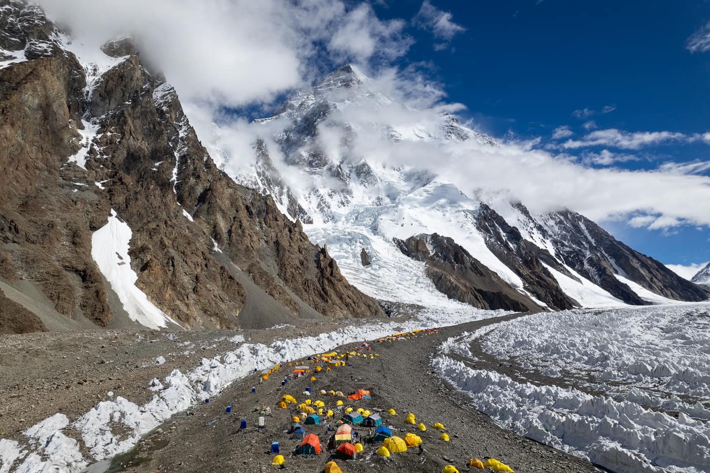
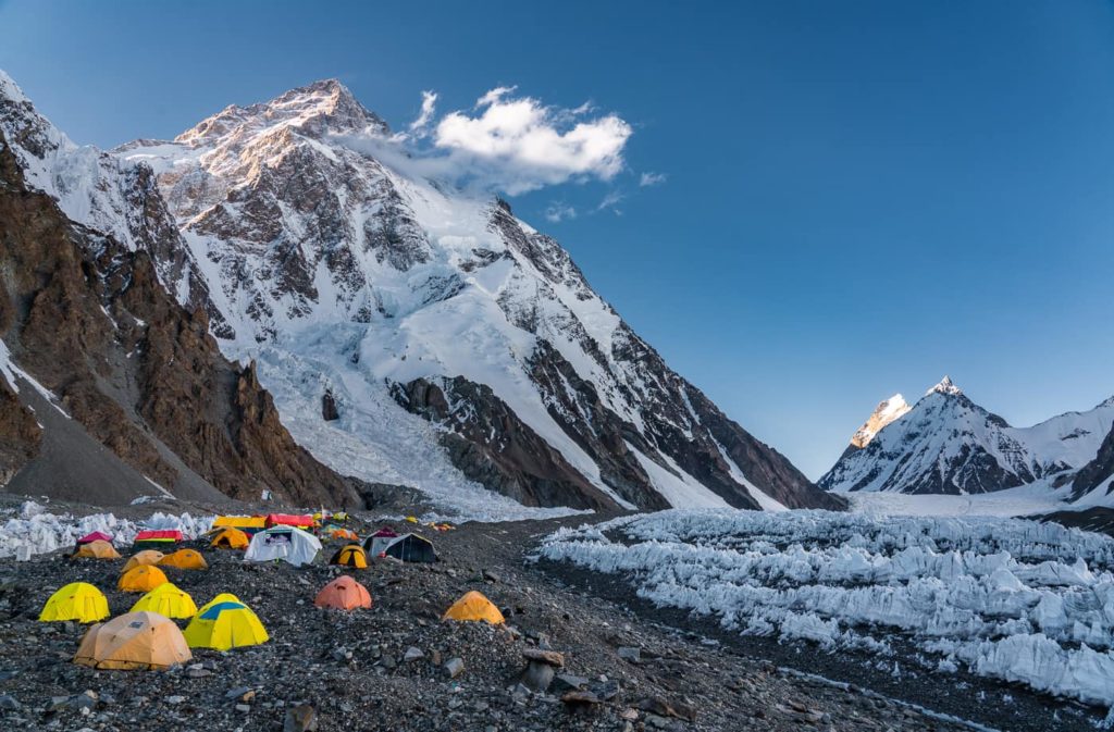
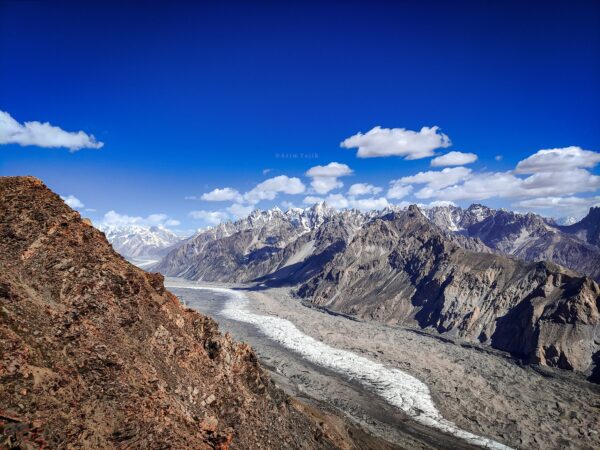
A special day today as we trek into Concordia and enjoy our first views of K2 (weather permitting). This location must be considered one of the world’s most spectacular camps as it is totally surrounded by stunning peaks. As we leave Goro II, the Biange Glacier to the north provides a superb view up to Mustagh Tower (7284m), one of the most difficult mountains in the Karakoram to climb. The trail continues along fairly easy rolling slopes of moraine marked by cairns and then passes among ice towers or seracs as we approach the colliding glaciers at Concordia. Mitre Peak (6030m) rises to our right, with Golden Throne (Baltoro Kangri) (7312m) beside it, while the Gasherbrum Group is directly before us. The expanse of Broad Peak (8050m) is to the left and finally, K2 (8611m) looms above the ridge towering over the Godwin Austen Glacier twelve kilometres away. Each mountain is different in character and its climbing history. It is awe-inspiring to know
that many of these mountains were explored and climbed upon around the turn of the century but were not submitted until the fifties and sixties due to their difficult technical routes and severe climatic conditions. One presumes they have little changed since these first explorations. Concordia, the junction of the Baltoro, Godwin Austen, Gasherbrum, and Vigne Glaciers, makes a perfect base from which to explore and enjoy some of the highest mountains in the world. Very few people are fortunate enough to witness this sight.
Our schedule is somewhat flexible according to the prevailing weather conditions and group preference. One of our objectives is to visit K2 Base Camp (approx. 5150m) and the Gilkey Memorial, a spectacular full-day trip from camp. The most exciting day of this trek as you walk past Broad peak and get nearer to K-2 and arrive at the strip which is the most popular camping area for nearly all the expeditions to K-2. Here some of the top climbers of the world can be seen busy in preparations for the challenges ahead. Return to your camp at Concordia overnight (K-2 base camp is too high and trekkers can get seriously ill from altitude if they stay for the night at this altitude, therefore the group must return to Concordia).
We will return by the no-less-spectacular journey back down the Baltoro glacier to the road head at Askole. Heading in a different direction, the views are always different and the weather always changing in the mountains; one could not consider this route as repetitious by anyone’s standards.
We begin the return trek descending first to Goro II where we have magnificent views of the surrounding granite spires and towers Camp.
We continue our descent of the Baltoro glacier, today reaching as far as Urdukas where we make camp off the glacier for the first time in several days.
Crossing the Baltoro to its north side beneath the towers of Uli Biaho we finally climb down its snout to reach a good trail back to the spring oasis of Paiju.
Following the Braldu River downstream, we make the detour into the Panma Valley to the bridge across its tributary to reach Jhola or Korofon.
The final day of trekking to the village of Askole. Here we say goodbye to our porters who will return to their villages.
Making an early start we drive to Skardu through the relatively verdant Shigar Valley. We check into the Hotel and the afternoon is free for sightseeing.
Day 20 will be used as a ‘cushion’ day in case of delays in travel due to weather, route change, health, acclimatization issues during the trek, etc.
There are many variations of passages of Lorem Ipsum available
Have a question before booking? Message us to learn more.
Login to use
Location
Duration
Embark on a guided adventure to Elephant Jungle...
Login to use
Login to use
Enjoy Bangkok’s rich history and spiritual heritage with...
Login to use
Location
Discover the beauty of the Frioul Islands Calanques...
Login to use
Ut enim ad minim veniam, quis nostrud exercitation ullamco laboris nisi ut aliquip ex ea commodo consequat. Duis aute irure dolor in reprehenderit in